
Backpacking and Fly Fishing Montana’s Beaten Path Trail

Author: Halie - Trails and Trout
Photography: Cole Leishman (coleleishman.com)
NOTE: The Beaten Path was affected by historic flooding in June of 2022. It’s reported that sections of trail are washed-out, the Rimrock Lake bridge is washed-out so this crossing is impassible, access to the East Rose Bud trailhead is inaccessible by vehicle (but accessible on foot with a “scramble”), and changes to lakes have occurred. The below description of our 2021 hike is not accurate at this time. Some sources say repairs are expected to be complete by September of 2023 but I have not verified this. I recommend researching the status of the roads/trail before planning a trip to this area.
Stop right there! Before you read about this magnificent wilderness and decide to plan your own adventure here, know the seven Leave No Trace (LNT) principles and how to appropriately implement them in this setting, if you don’t already. LNT consideration is an integral part of trip planning. We can’t be outdoor enthusiasts without also being good stewards of the outdoors. I hate to sound harsh, but those who aren’t willing to responsibly recreate in our shared outdoor spaces should skip the trip. To learn more, visit lnt.org/why/7-principles/ and then scroll to the bottom of this blog to check out a few highlighted LNT considerations for this trip.
Background
The Beaten Path is the bucket list hike that I didn’t even know was on my bucket list until I was seeing it for myself. Imagine a backcountry landscape abundant with cascading waterfalls, alpine lakes and impressive peaks, where there’s a new breathtaking view around every corner of trail. That’s the Beaten Path. This is a popular, 26 mile, point to point hike, through Montana’s 944,000-acre, Absaroka-Beartooth Wilderness, within the Custer Gallatin National Forest.
The Beaten Path can be hiked in either a west to east, or an east to west orientation. From west to east, the route begins near Cooke City at the Clarks Fork Trailhead (called the Clarks Forks Picnic Area on Google Maps). The Clarks Fork Trailhead is off of the Beartooth Scenic Byways which is largely revered as one of the most beautiful stretches of road in the United States. The trailhead is also just a short distance northeast of the Yellowstone National Park border. From the Clarks Fork Trailhead, the route follows the Russell Creek Trail for approximately 10 miles to Fossil Lake. There, the trail crosses into a different ranger district and becomes the East Rosebud Trail. The route follows the East Rosebud Trail for another 16 miles, and ends at the East Rosebud Trailhead which is at the end of East Rosebud Road.
The East Rosebud Trail begins at significantly lower elevation than the Clarks Fork trail, 6,280 feet compared to about 8,000. Therefore, hiking from the Clarks Fork trailhead is the easier option with less elevation gain. I’ve seen different accounts of the elevation gain when hiking from the Clarks Fork trailhead to East Rosebud, but we tracked that it was roughly 3,700 feet. Some people prefer hiking from Rosebud to Clarks Fork, reporting that the views are better. However, I didn’t feel there was any shortage of breathtaking scenery while hiking in the orientation we chose.
While the Beaten Path route itself is 26 miles, opportunities for side excursions abound. There are hundreds of lakes in the Absaroka-Beartooth Wilderness. The Beaten Path passes 15 lakes directly, and many more are just a short jaunt from the main trail. If you’re planning this hike and can dedicate some extra time to side excursions, I highly recommend it, but be aware that there aren’t always established trails to other lakes and route finding skills may or may not be necessary. There is certainly rugged, sheer terrain in this wilderness - the Beartooth mountains are home to the highest 41 peaks in Montana - but I’ve also found that there’s a good mix of rolling, accessible terrain that often allows for easy scrambling between destinations without established trails.
Our Trip
My partner and I backpacked the Beaten Path with our two dogs in August of 2021, starting in Cook City and ending at East Rosebud. We did this hike in two nights and three days. We still had an amazing trip, but wish we could’ve dedicated more time to it. It would have been ideal to not rush and have plenty of extra time for fishing and side excursions “off the beaten path.”
Day 1: We began our hike from the Clarks Fork Trailhead. The parking lot was large but almost full. We knew this was a popular trail and did pass other groups, but nothing ridiculous. “Busy” in the vast, Montana wilderness still allows for periods of solitude.
The first roughly 0.1-mile of trail is technically called the Clarks Fork Trail, until it passes over a bridge on the Clarks Fork of the Yellowstone River, and is then labeled on the map as the Russell Creek Trail. This entire, first section of the hike is more densely forested. The trail continues to follow the Clarks Fork of the Yellowstone River for a short jaunt, until it becomes the Broadwater River, then Sedge Creek. The first major lake we passed, less than two miles from the trailhead, was Kersey Lake. It’s a large, pretty lake but not quite as stunning as the ones to come. Past Kersey Lake, the hike follows Russell Creek, which is accessible from the trail in many spots. We stopped at the creek several times for snack breaks, to let the dogs get a drink, admire cascading waterfalls and/or bust out our fly rods. Russell Creek was full of small but aggressive brook trout that were eager to eat our flies.

Photo by Cole Leishman. A small brook trout explodes on my fly while fishing Russell Creek on Montana’s Beaten Path.

Photo by Cole Leishman. A small but vibrant brook trout from Russell Creek in the Montana Backcountry.
The next notable lake we came upon, about 6.2 miles from the trailhead, was the beautiful Russell Lake. I felt that the first section of the trail had been pretty flat, but steepness picked-up as we approached Russell Lake. This was also about the section where the trail started to become a bit less forested, less shady in spots, and rockier (a consideration for your dogs paws, especially if hiking with dogs in the summer heat). We stopped at Russell Lake to have lunch and fly fish. Again, there were small brook trout in the lake and its outlet. We could tell this spot was more pressured because the fish were pickier and we actually had quite a few reject our flies. If I’m being honest, I didn’t feel the need to swap flies, reduce tippet size, etc., just to try to trick some little trout, so we moved on. There were a few good campsites at Russell Lake and we would’ve loved to swipe one if we hadn’t needed to cover mileage. One of the first sets of true switchbacks was just past Russell Lake, but still, I personally didn’t feel that it was too grueling - In fact, I felt that that elevation gain throughout this entire hike was comparatively slow and steady. Also, just past Russell Lake is the turnoff trail for Mariane Lake. We ran into other hikers who had camped at Mariane the night before and recommended it, but we were on a tight agenda and opted to skip it. It’s approximately 1.5 miles to Mariane Lake, one way.

Photo by Cole Leishman. Fly fishing at Russell Lake on Montana’s Beaten Path.
About a mile and a half past Russell is the small but gorgeous Ouzel Lake. We were hot from climbing the exposed switchbacks, so upon reaching Ouzel, we stripped down and took a quick dip. Right around the corner from Ouzel is yet another smaller, breathtaking lake, Bald Knob Lake. There were quite a few great campsites in this section. Approximately half a mile past Bald Knob is Skull Lake which is again, small but beautiful. In this section, the terrain really begins to “open up,” into that quintessential, bouldery, rolling, alpine topography that one imagines when they think of the Absaroka and Beartooth Mountains.

Photo by Cole Leishman. The Beaten Path trail passes Skull Lake, an alpine lake in the Beartooth Mountains.
Roughly one mile past Skull Lake is Fossil Lake. But, we wouldn’t yet be heading to Fossil because this is where we planned our first, short offshoot. We identified a lake near Fossil where we hoped to camp on Night 1. We saw the lake’s outlet and hiked up it. There were certainly signs that others do this, but we didn’t find a single, established trail so we did our best to rock-hop and stay on durable surfaces. We made it to the lake and looked for an established site or durable surface, 200 feet from the water, where we could set up camp. We didn’t see any established sites or flat rock slabs, so we put our tent on a small, gravelly patch on a ridge above the lake, and otherwise tried to follow LNT principles for camping in undisturbed areas - this included avoiding repetitive traffic routes, cooking/hanging out on rocks, etc. We rested, snacked, then headed down to lake with our fly fishing gear, cooking stuff, and water filter/vessels. We fished, had dinner and restocked our water supplies. Granite Peak, Montana’s highest, could be seen to the north.
The lake was loaded with small brook trout, and I’m talking a fish-on-every-cast kinda loaded, but all in the size range of six inches, so nothing too exciting. You hear about turnover in the size of fish in alpine lakes, especially with brook trout, in which a lake will either have tons of small fish or fewer, larger fish, but not both at the same time. This lake, and the whole west side of the Beaten Path, for that matter, seemed to be in the tons-of-small-fish phase. I imagine the growing season is very short and the food supply is limited in this environment, too.

Photo by Cole Leishman. A lake outlet that we scrambled up.

Photo by Cole Leishman. Our Night 1 campsite on the Beaten Path.
Day 2: The morning of Day 2, we had breakfast, packed up camp, walked back down to the main trial and headed to Fossil Lake. We discovered there was an easier jaunt from the lake to the main trail on the far (east) side of it. The landscape surrounding Fossil Lake is huge, open and impressive. This is also the highest elevation that the Beaten Path reaches, just under 10,000 feet. It’d all be downhill from here (in a goo way)! We of course, busted out our fly rods. This is the first place we caught cutthroat trout, rather than brook trout. On average, they were larger than the brookies, but still nothing to write home about. This is usually to be expected in a harsh, alpine environment. For me, being able to fly fish in such a magnificent setting was the point of the trip, not the size of the fish. The trail went right along the edge of the lake, then East Rosebud Creek (the Fossil Lake outlet is the origin of East Rosebud Creek), for quite some time. There were colorful wild flowers in bloom all through this area.

Catching a trout on the fly at Fossil Lake without even having to drop the backpack!

Photo by Cole Leishman. Wild flowers in bloom near Fossil Lake on the Beaten Path trail of Montana.
We continued our trek and just when I thought it couldn’t get any more breathtaking, we made it to the back-to-back Dewey Lake and Twin Outlets Lake. Mount Dewey, with its massive, glaciated, granite walls loomed behind the turquoise water. It wasn’t just the lakes themselves, but the waterfalls that cascaded over rocky slabs between the inlets and outlets. Of course, we wetted our fly lines in these lakes. Again, fishing wasn’t anything spectacular, but we caught a few, beautiful, colorful, alpine cutties. It also seemed that fish became pickier the further east we trekked (this makes sense given the trail got busier and busier the closer we got to East Rosebud, which was by far the most populated area of the whole hike).

Photo by Cole Leishman. The cliffs behind Dewey Lake.

Photo by Cole Leishman. Fly fishing for Yellowstone Cutthroat Trout in Dewey Lake off Montana’s Beaten Path.

Photo by Cole Leishman. A Yellowstone Cutthroat Trout caught while fly fishing the Beaten Path in the Montana Backcountry.

A cell phone photo I took of cascading waterfalls just below Twin Outlets Lake on Montana’s Beaten Path Trail.
We continued our descent and about half a mile past the outlet of Twin Outlets Lake, the creek that the trail followed suddenly seemed to disappear from the face of the Earth. We had come to the incredible Impasse Falls, the largest falls on the hike, just above Duggan Lake. Seriously, how do things just keep getting more spectacular as we lose elevation?! The trail was initially far above above Duggan Lake but dropped down to lake-level near it’s outlet. We didn’t stop here because we’d taken our time fishing earlier in the day and were now in a hurry, not knowing for certain where we’d be camping this night. There were a few campsites at Duggan Lake, but be aware that this entire section of trail, until reaching Rainbow Lake, has far fewer campsite options. Part of this is due to the steep topography of the area. Remember to follow LNT principles by camping 200 feet from alpine lakes and streams.
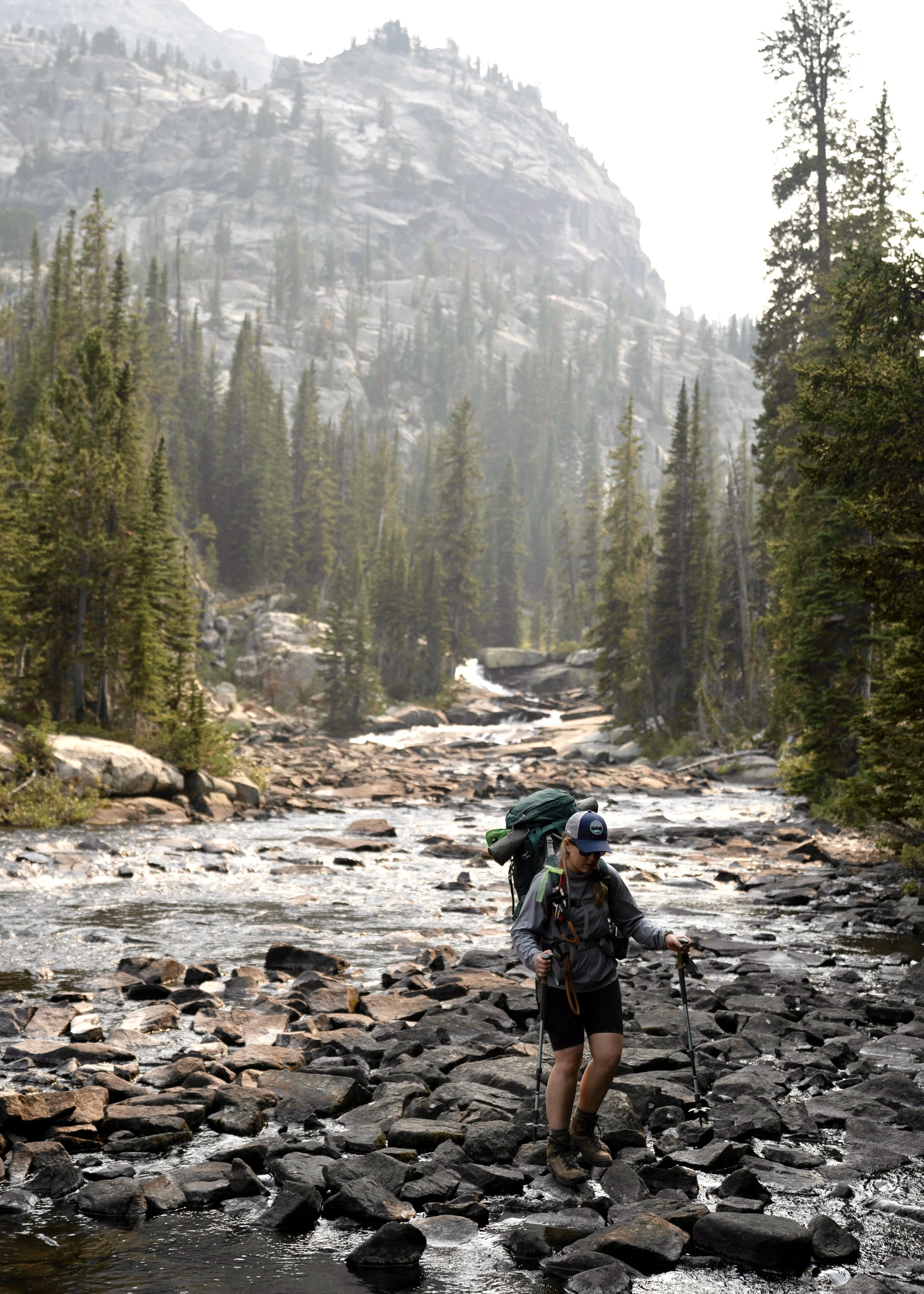
Photo by Cole Leishman. Continuing our hike down along East Rosebud Creek.

Photo by Cole Leishman. Water plunges down Impasse Falls into the Duggan Lake inlet on Montana’s Beaten Path Trail.

Photo by Cole Leishman. An impressive peak and waterfall past Duggan Lake on the Beaten Path trail of Montana.
Roughly two miles further, we reached Big Park Lake. The contrast between Big Park and the other lakes in this section is interesting. While the other lakes boast open, rugged, rocky, and steep shorelines, Big Park appears flat, shallow, densely vegetated, and emerald green. It was the perfect spot for the dogs to take a quick dip. I can’t say exactly why, but I was on high grizzly bear alert through this section. Maybe it was because late huckleberries lined the trail, or just because we were suddenly back in a tightly forested strip of habitat that felt like a perfect bear-refuge among all the granite. We were in a hurry and did not fish here.

Photo by Cole Leishman. Traversing a section of dense forest before Big Park Lake on the Beaten Path trail, Montana.

Photo by Cole Leishman. Admiring Big Park Lake on the Beaten Path Trail of Montana.
Just past Big Park, the trail traverses high above Lake at Falls. It’s named after the multiple, incredibly high waterfalls that plunge down huge granite faces lining the lake. The water comes from lakes and glaciers above Lake-at-Falls, which are out of view from the trail. At this point, we were in a hurry to make it to a campsite at the intlet of Rainbow Lake, about a mile further. Campsites abound near the inlet of Rainbow. This was a popular area with quite a few other campers. We found a place to store our food and scented items 100 feet from the camping area (remember not to bring these items into your or anyone else's campsites - find more details on how to stay safe in grizzly bear country in “LNT Considerations” at the bottom of this page). We then found an established site to pitch our tent, walked down to the lake to get water, and back to our food-storage area to have dinner. After this, we hung out at the lake and briefly tried to fish. Though we put in minimal effort, we had no luck. With the popularity of Rainbow Lake, l imagine lots of folks keep and cook fish here so there are just fewer biters around, especially this late in the season and so close to the main camping area. I hoped to get a restful sleep this night but I had grizzly bears on my mind and woke to every, slight noise. In grizzly country, I find it much more nerve-racking to camp in high use areas, around other people, than to camp in solitude. Who knows if the folks in the neighboring sites stored food properly? Who knows if the people who camped in our site before us cooked in it? They could’ve spilled bacon grease everywhere, for all I know.

Photo by Cole Leishman. My dog takes a dip in Rainbow Lake on Montana’s Beaten Path trail.
Day 3: We made it through the night with no bear encounters. After breakfast, we packed up camp and hit the trail, with about 7.5 miles left to the trailhead. Past the inlet/camping area, much of the trail along Rainbow is high above the lake, and quite stunning. Rainbow Lake is almost a mile long.
Just beyond Rainbow is Rimrock Lake. As the name suggests, it has a mostly steep, rocky shoreline. The trail traversed a wooden bridge over the outlet of the lake. As I mentioned at the beginning of the blog, this area was heavily modified by historic flooding in June of 2022 - after the 2021 trip I’m writing about. Reports say that sections of trail in this area are washed-out, the Rimrock bridge is washed-out, and that Elk Lake was nearly erased. I plan to finish this trip report as I experienced it, but don’t know if it will reflect future trail conditions.

Photo by Cole Leishman. The Beaten Path trail traverses above Rainbow Lake.
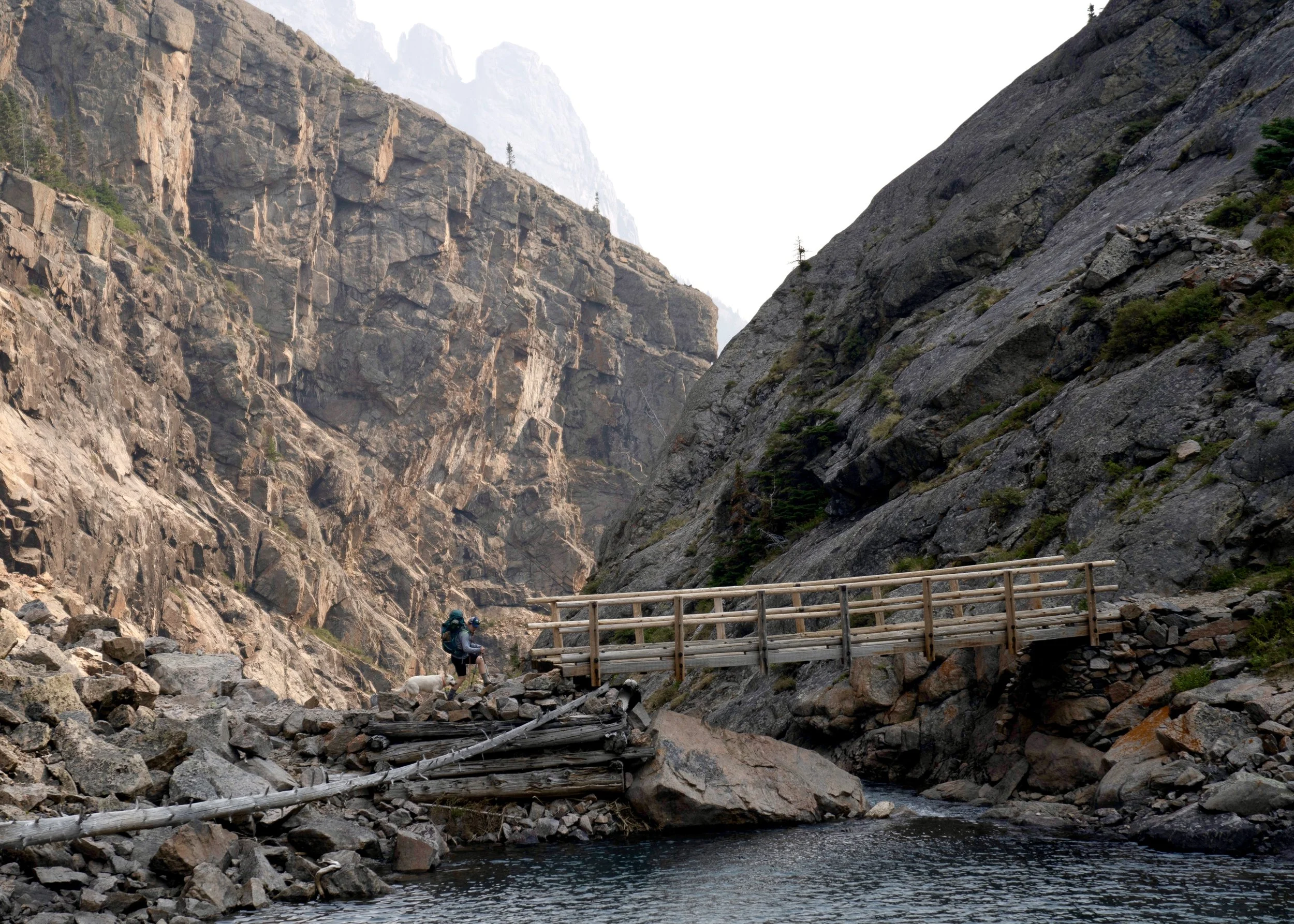
Photo by Cole Leishman. Crossing the bridge over the outlet of Rimrock Lake on Montana’s Beaten Path trail.
It was roughly two miles past Rimrock Lake to Elk Lake. The section of trail below Rimrock Lake was some of my favorite on the entire hike. The landscape temporarily tightened between impressive, granite peaks and East Rosebud creek cascaded on the valley floor far below the trail. The scenery opened up some upon reaching Elk Lake, but jagged peaks still scoured the skyline. We stopped to fish near the inlet of Elk Lake and caught a few more, small trout. Again, the trail just got busier and busier the closer we got to the trailhead, and we could tell the fish were more pressured, because they continued to get pickier, too. Elk Lake would be the last we passed before making it to East Rosebud Lake at the trailhead. It was just over three miles from the outlet of Elk Lake to the parking lot. Because we had taken our time fishing, we got caught in the heat of the day in this fairly exposed section of trail. I worried about my dog’s feet but thankfully, it wasn’t hot enough to bother them. There were also some areas where we could make it down to the creek and cool off. By the time we reached the parking lot we were exhausted, but our heart were full from the incredible wilderness experience we’d just had.

Photo by Cole Leishman. Fly Fishing East Rosebud Creek near the inlet of Elk Lake on Montana’s Beaten Path trail.

Photo by Cole Leishman. Jagged peaks line the horizon near Elk Lake along the Beaten Path trail in Montana’s Absaroka-Beartooth Wilderness.
A few additional notes about our trip - While this trail was certainly strenuous considering length alone, and there were steeper sections of trail, I felt that the elevation was spread out fairly evenly across the 26 miles. Western Montana’s 2021 fire season was pretty miserable at points. As can be seen in the photos, there was a bit of smokey haze during our trip. Thankfully, we caught a good window and it never got too bad. There were a few mosquitos around but respectively, not that many. I’ve read reports of them being miserable on this hike. It seemed like they were worse at lower elevations on the west side of the trail, closer to the “swampier” stuff. We had no notable wildlife sightings during our trip.
Shuttle/Key Swap
Certainly a more challenging component of this hike is planning a shuttle or key swap, given it’s a point to point trek. We opted for a key swap with a stranger. This was a bit nerve wracking-racking and many what-if scenarios ran through my head: What if they don’t show up and their car isn’t at the trailhead? What if one of us has car trouble? What if they steel our car? What if I get in an accident in their car? Spoiler, none of those things happened and the swapped worked out nicely.
We found our key swap buddy by posting a review on AllTrails. We included the dates we planned to hike and asked if anyone else hiking the same dates would be interested in exchanging keys. Someone replied that they we were interest, we traded contact info, and hashed out the details. They hoped to hike east to west, so we agreed to hike west to east. We initially discussed trading keys as we passed each other on the trail. However, my partner and I wanted to do some side excursions and we didn’t know exactly when we’d be on or off of the main trail, so we worried about missing the other driver. We and the other driver decided to respectively hide our car keys in a hide-a-key, locked on the outside of our cars, which would be parked at the respective trailheads. Of course, we had told each other what cars to look for and where the keys would be hidden.
When my partner and I finished the hike at the East Rosebud Trailhead, we found their car and key, and drove to a brewery in Red Lodge, where we planned on meeting to exchange cars. Because it’s hard to know exactly what pace we’d keep and precisely when we’d finish the hike, we planned to meet within a window of several hours. The other party ended up surpassing the latter end of that window and we started to get nervous while waiting for them. They obviously wouldn’t have cell service on the trail to let us know if they were running late. They showed up and it turned out they were just tired and hiking slower than expected.
If my partner and I had decided to run our own shuttle, we would’ve spent twice as much in gas, because we would’ve had to drive two cars. We also wouldn’t have been able to ride together, and we would’ve spent a lot more time driving because it’s a long shuttle. The trailheads are about three hours apart, so that’d make the shuttle six hours?
Highlighted LNT Considerations for this Trip
This is NOT an exhaustive list of LNT principles to practice on this hike. These are only a specific, highlighted few. If you’re not familiar with all seven principles, visit lnt.org/why/7-principles/.
Where to travel and camp: When traveling where there’s an established trail, of course, stay on trail. If fly fishing or just hanging out along lake shorelines and streams, try to stay on rock/gravel/sand as much as possible and avoid trampling shoreline/riparian vegetation. Among many other things, this vegetation is important for the bugs that feed the trout. There’s a lot of off-trail, side excursion opportunity in this wilderness. Remember to travel on durable surfaces as much as possible if venturing beyond an established trail. When deciding where to setup camp, pick established sites or durable surfaces, like rock slabs and gravel patches, and avoid vegetation. Camp 200 feet from water sources like alpine lakes and streams.
Human Waste: Popular backcountry spaces are increasingly being polluted with human waste. In fact, camping has even been banned in some places because of fecal contamination. I highly, highly encourage folks to consider packing out their waste with the use of WAG bags instead of digging cat holes. I almost always do this, especially in sensitive alpine ecosystems like much of the Beaten Path. It’s not difficult to do. Bring a trash bag or sacrificial dry bag to put the WAG bags in, then your poo is triple bagged. If you MUST dig a cathole, be sure it’s six inches deep, 250 feet away from water, NOT in a sensitive habit (like alpine meadows/vegetation), and for the love of all that is good, pack out toilet paper. I have seen SO MUCH unburied human feces and nasty, dirty toilet paper in wilderness - right at campsites, right near the water - not only is this a literal biohazard for other campers and HORRIBLE for water quality, it’s littering and it’s just disgusting. Okay, I got heated for a second but my rant over.
Bear Awareness: The Beaten Path traverses a region with a dense grizzly bear population. Always carry bear spray where it’s immediately accessible and know how to use it. Frequently make noise on the trail by talking, yelling, and clapping. Travel in groups. Do not leave food or other scented items including cookware, fuel canisters, toiletries, or trash unattended. Do not bring these items into your campsite. Store them in a bear safe canister or proper bear hang at least 100 feet from your (and others’) camp. A proper bear hang requires 25 feet of rope and a bag large enough to store all mentioned, scented items. Hang the bag from a tree limb 15 vertical feet high and ten horizontal feet away from the tree trunk. Cook and Eat 100 feet away from your camp. Consider cooking in different clothes then the ones you will wear in camp/sleep in and make sure you don’t get food on the clothes you plan to sleep in. As discussed below, do not have dogs that don’t have a reliable recall off leash in grizzly bear habitat.
Dogs: Always pack out dog waste. Again, this is especially important in sensitive alpine ecosystems. Pick it up and don’t leave the bags on trail. There is a leash law on the Beaten Path. I’m a huge dog lover and personally don’t feel that all dogs should always be leashed, but the off-leash dog situation on this trail was pretty out of control. I was jumped on, a full size Great Pyrenees rammed past my legs on steep terrain, a dog with no owner in sight came into our campsite and antagonized our leashed dogs, a husky (100 yards ahead of it’s owner, ignoring her as she called) tried to steal my lunch, and many other off leash dogs charged right up to our dogs. Here’s where I draw a hard line: Dogs that don’t have a really good recall shouldn’t be off leash in public, outdoor spaces - even if there aren’t leash laws and even if the dog is friendly. It’s basic hiking etiquette and common courtesy. This is particularly important on popular trails, when around other hikers, around hazardous/steep terrain, and especially when in grizzly bear country. Letting poorly trained dogs off leash is not only only annoying and disrespectful to other hikers, it’s bad for LNT if dogs trample sensitive areas off trail, and it can be incredibly dangerous if a dog were to antagonize a grizzly bear. This is a leading cause of bad grizzly encounters. Unlike black bears, which often run from barking dogs, a grizzly bear is likely to anger and charge the barking dog. The dog usually startles and runs back to the owner with the angry grizzly bear in pursuit. Dog owners should also be aware that this trail has a ton of sharp rock that will tear up a dog’s feet if they aren’t acclimated to it. We passed a few dogs that obviously had sore feet. Our dogs had been hiking and running around on river rock all season at this point, so they were fine. I’d recommend doggie boots to anyone who’s unsure. Also, the trail is exposed in many areas and can get very hot in the summer sun which can burn dogs feet.
Fish Handling: Please follow all current fishing regulations. If you don’t know them for an area, look them up before fishing. If practicing catch-and-release, please follow ethical fish handling practices, especially with trout because they’re more sensitive. This includes keeping fish in the water as much as possible, not fishing when water temperatures are too hot, using barbless hook, using rubber/no-knot nets, not squeezing fish or touching their gills, etc. For details, check out keepfishwet.org.
Here are a few resources that helped us plan:
To check out the gear I used on this trip, visit my RockPorch profile: https://app.rockporch.com/prf/halieoutdoors